Mapping Personal Success Through GIS Innovation
Published April 7, 2025
 As a junior pre-med major at Stony Brook University, Mary Bracho had an epiphany. Enrolled in an organic chemistry class with 600 students, she felt unseen, unfocused, and unsure of her future. A Venezuelan-born, first-generation college student, she realized that the pre-med track was no longer aligned with where she wanted to go in life.
“I had lost my passion and my why,” said Bracho. “My academic counselor suggested that I take an elective course, and I enrolled in Introduction to Climate and Climate Change. The professor, Dr. Yager, was so passionate about the research she was doing that I wanted to do whatever that was. I switched my major.”
Turns out that what Dr. Yager was doing was research that coupled social ecological systems with Land Cover Land Use Change – a part of Geographic Information Systems. Bracho had the opportunity to join Dr. Yager to support the remote sensing analysis portion of a field trip to Bolivia. While in the Andes, she spent time studying the impact of disappearing tropical glaciers on pastoral agriculture and water sources through satellite imagery analysis. The experience opened her eyes to the importance of GIS and the varied opportunities that the field offers. Realizing that GIS was her path forward, she eventually enrolled in the Johns Hopkins’ MS in Geographic Information Systems program and graduated in 2021.
“Enrolling at Johns Hopkins has been the best investment in myself and my professional career,” she said. “The professors are amazing, and they are at the center of innovative solutions. The courses were awesome – varied and applicable – everything from emergency management and drone courses to cartography. I would 100,000% recommend Johns Hopkins to anyone with an interest in GIS. The program validated my knowledge and my place in the professional environment, helped me build meaningful connections, and really solidified that this is the work that I want to do.”
Bracho dove into the discipline, first as a NASA LCLUC research assistant, funded by Research Opportunities in Space and Earth Science. Then she worked as a research associate GIS specialist at the Orentreich Foundation for the Advancement of Science. After which she found her way to Blue Raster, a company that leverages the full power of geospatial intelligence to help clients share their stories through GIS, web, and mobile applications. The company has partnered in highly visible projects for some of the world’s leading organizations in the fields of conservation, health, government, global affairs, and education.
“I like to say that what I do at Blue Raster is ‘GIS for Good’,” said Bracho, now a Senior GIS Analyst. “My position allows me to take my passion for automation through Python coding and my love of GIS to use geographic data to tell stories and assist in important decision-making, along with mentoring and leading professionals with the same mindset.”
 In her role, Bracho has worked on high-profile projects for the Jane Goodall Institute, National Geographic Society, and the Columbia University Mailman School of Public Health. Her work with the American Red Cross supported the Disaster Partner Hub that assisted with planning, preparedness, response, and recovery to disasters. To enhance the efforts in Saratoga County, NY, with opioid education, prevention, treatment, and response efforts, Bracho created a Python script to automate the weekly update of datasets garnered from various departments, Her work with key metrics on substance use – shown through various graphs, charts, and a map by zip code – assisted in the creation of a near real-time, easy-to-navigate dashboard. The dashboard houses informative data as a resource to Saratoga County professionals in law enforcement, public health, and mental health, as well as community partners who focus on substance-use support services.
Bracho also has used her GIS background to address Georgia’s state- and county-level redistricting concerns for voting and election purposes.
“We were able to geocode nearly eight million registered voters and report the outputs two to three times a week using ArcGIS StreetMap Premium and Python,” she said. “This project helped election officials ensure voters were assigned to the proper polling places after redistricting by visualizing inconsistencies within the system. It opened a new way of looking at data found in the voter record file for election officials, ensured consistent reporting of voter record review progress, and obtained an official sign-off of completion from Georgia’s Secretary of State. This solutions-based emphasis is something that I really like about GIS work.”
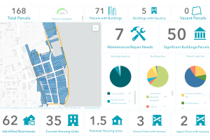
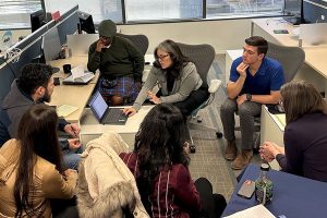
Currently, Bracho is working with the nonprofit Main Street America, a National Trust for Historic Preservation subsidiary. She has developed scripts using geographic data to support the creation of a desktop and mobile app – the BOOMS Tracker – Building Opportunities on Main Street. The tool helps address the need to revitalize Main Street districts across America that are critical for preserving cultural heritage, fostering economic growth, and enhancing community resilience.
“Because of our work, updates are provided daily at 5 p.m. allowing for an inventory of parcel data that is being submitted by approximately 1,400 volunteers who are in the field and doing surveys with apps that we have created in collaboration with MSA,” Bracho said. “We have even gamified the process with a leaderboard to incentivize data collection. How many parcels have been inventoried? What Main Street has made the most progress? This work has even created an unexpected dataset with over 3,000 images that have been collected, including photos of the original land deeds and really great shots of some of America’s iconic Main Streets. And for the public, there is an interactive map, you can zoom in and out, click on it and get a pop up with additional information. All of this is available because of GIS.”
Bracho finds fulfillment by infusing creativity into her work, making data accessible and understandable, and developing solutions that inspire community engagement and action.
“All of these maps and applications and data points that are being created through GIS technologies allow for a wider dissemination of data and knowledge sharing in real time,” said Bracho, a panelist at JHU’s HOP25 Symposium focused on 21st century environmental challenges. “I am a big believer in the more we share, the more people know, and the better we all are for it. I always tell my family. ‘I don’t know what I want to do when I grow up,’ even though I am grown. I think that is because this field has given me so many ways to contribute in a positive way, and I am still searching for the perfect balance between technical work, leadership, and passion for new innovations that allow for even better storytelling.”
Attention: Students and Alumni
Are you a current AAP student or alumni and want to share your accomplishments?
Interested in pursuing a graduate degree at Johns Hopkins University?
Request information to learn more or apply here.